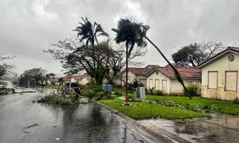
Earlier this week, Typhoon Mawar whipped up tension in western Micronesia as the category 4 storm came close to landfall on the island of Guam. Starting out as a tropical depression over the weekend, Mawar rapidly deepened and intensified over the following couple of days, almost reaching category 5 by Tuesday evening. Wind gusts peaked at 155mph (250km/h), briefly making Mawar a super typhoon about 100 miles south-east of the US island territory.
In a stroke of luck, an eyewall replacement cycle occurred overnight, hours before the super typhoon was due to reach Guam. The cycle involves the slight degradation of the storm’s structure as a new eye develops around the old eye. Consequently, the storm’s intensity weakened temporarily while simultaneously spreading strong winds over a larger area. Mawar’s winds dropped to a sustained speed of 140mph as the typhoon brushed the northern edge of Guam at about 7am local time (2200 BST). Had Mawar made landfall, it would have been the first category 4 typhoon to do so since Typhoon Omar in 1992.
Strong winds and heavy rain brought Guam to a standstill with 98% of the approximately 150,000 inhabitants losing power for up to a few days. Despite this, a powerful storm surge, and a large amount of debris, there have been no reports of deaths or injuries so far.
Having passed Guam, Mawar headed north-west across the Philippine Sea, reintensifying into a category 5 super typhoon with sustained winds of 170mph. Current meteorological models forecast Mawar’s intensity will steadily decline to a category 2 typhoon before reaching the vicinity of the Philippines and Taiwan. While less powerful than what Guam has experienced, winds of at least 95mph will be possible.
In south-east Spain, the regions of Andalusia, Murcia and Valencia experienced spells of persistent and heavy rain on Tuesday, with hourly rainfall totals of up to 40mm. One site in Ontinyent, Valencia, recorded the maximum amount of rainfall of 240mm in a 24-hour period. After months of dry weather and a spring heatwave, such quantities of rainfall struggled to infiltrate soils, resulting in flash floods affecting almost 400,000 people.
